LEGISLATIVE HISTORY
(February 13, 2004)
Planning & Zoning Committee

ORDINANCE NO. BL2003-87
An ordinance to amend Title 17 of the Metropolitan Code of Laws, the Zoning
Ordinance of The Metropolitan Government of Nashville and Davidson County,
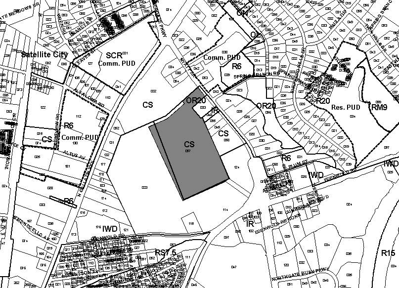
by changing from CS district to IR district part of a parcel at Myatt Drive
(unnumbered), located approximately 1,000 feet south of North Gallatin Pike
along the west side of Myatt Drive (27.12 acres), all of which is described
herein (Proposal No. 2004Z-003G-04).
NOW, THEREFORE, BE IT ENACTED BY THE COUNCIL OF THE METROPOLITAN GOVERNMENT
OF NASHVILLE AND DAVIDSON COUNTY:
Section 1. That Title 17 of the Code of Laws of The Metropolitan Government of Nashville and Davidson County, is hereby amended by changing the Official Zoning Map for Metropolitan Nashville and Davidson County, which is made a part of Title 17 by reference, as follows:
By changing from CS district to IR district part of a parcel at Myatt Drive
(unnumbered), located approximately 1,000 feet south of North Gallatin Pike
along the west side of Myatt Drive (27.12 acres), being more particularly described
as part of Property Parcel No. 57 as designated on Map 34-06 of the Official
Property Identification Maps of The Metropolitan Government of Nashville and
Davidson County, all of which is described by lines, words and figures on the
attached sketch, which is attached to and made a part of this ordinance as
though copied herein.
Section 2. Be it further enacted, that the Metropolitan Clerk is hereby authorized
and directed, upon the enactment and approval of this ordinance, to cause
the change to be made on Sheet No. 34 of said Official Zoning Map for Metropolitan
Nashville and Davidson County, as set out in Section 1 of this ordinance,
and to make notation thereon of reference to the date of passage and approval
of this amendatory ordinance.
Section 3. Be it further enacted, that this ordinance take effect immediately after its passage and such change be published in a newspaper of general circulation, the welfare of The Metropolitan Government of Nashville and Davidson County requiring it.
Sponsored by: Rip Ryman, Jim Gotto
Map-Parcel No./Owner:
34-06 Part of 57
Rivergate Partners
Requested by:
Walter Knestrick
|
LEGISLATIVE HISTORY |
|
|---|---|
| Introduced: | December 2, 2003 |
| Passed First Reading: | December 2, 2003 |
| Referred to: | Planning Commission – Approved 8-0 (February 13, 2004) Planning & Zoning Committee |
| Passed Second Reading: | January 6, 2004 |
| Deferred to February 17, 2004 | January 20, 2004 |
| Passed Third Reading: | February 17, 2004 |
| Approved: | February 18, 2004 |
| By: | |
| Effective: | February 19, 2004 |