LEGISLATIVE HISTORY
Planning & Zoning Committee

ORDINANCE NO. BL2003-52
An ordinance to amend Title 17 of the Metropolitan Code of Laws, the Zoning
Ordinance of The Metropolitan Government of Nashville and Davidson County,
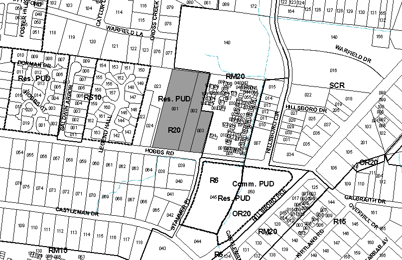
by changing from R20 district to RM4 district properties at 2122, 2124 and
2200 Hobbs Road located on the north margin of Hobbs Road and the northern
terminus of Stammer Place, (5.08 acres), all of which is described herein,
(Proposal No. 2003Z-128U-10).
NOW, THEREFORE, BE IT ENACTED BY THE COUNCIL OF THE METROPOLITAN GOVERNMENT
OF NASHVILLE AND DAVIDSON COUNTY:
Section 1. That Title 17 of the Code of Laws of The Metropolitan Government of Nashville and Davidson County, is hereby amended by changing the Official Zoning Map for Metropolitan Nashville and Davidson County, which is made a part of Title 17 by reference, as follows:
By changing from R20 district to RM4 district properties at 2122, 2124 and
2200 Hobbs Road located on the north margin of Hobbs Road and the northern
terminus of Stammer Place, (5.08 acres), being more particularly described
as Property Parcel Nos. 1, 2 and 3 as designated on Map 131-02 of the Official
Property Identification Maps of The Metropolitan Government of Nashville and
Davidson County, all of which is described by lines, words and figures on the
attached sketch, which is attached to and made a part of this ordinance as
though copied herein.
Section 2. Be it further enacted, that the Metropolitan Clerk is hereby authorized
and directed, upon the enactment and approval of this ordinance, to cause
the change to be made on Sheet No. 131 of said Official Zoning Map for Metropolitan
Nashville and Davidson County, as set out in Section 1 of this ordinance,
and to make notation thereon of reference to the date of passage and approval
of this amendatory ordinance.
Section 3. Be it further enacted, that this ordinance take effect immediately after its passage and such change be published in a newspaper of general circulation, the welfare of The Metropolitan Government of Nashville and Davidson County requiring it.
Sponsored by: Lynn Williams
Map/Parcel No.:
Map 131-02, Parcels 1,2 and 3
Owner:
Ernest E. Hyne et ux
Paul CUnningham et ux
Terry R. Quillen
Requested by:
Gresham-Smith and Partners
|
LEGISLATIVE HISTORY |
|
|---|---|
| Introduced: | November 18, 2003 |
| Passed First Reading: | November 18, 2003 |
| Referred to: | Planning
Commission - Approved7-0 (10/23/2003) Planning & Zoning Committee |
| Passed Second Reading: | January 6, 2004 |
| Passed Third Reading: | January 20, 2004 |
| Approved: | January 21, 2004 |
| By: | |
| Effective: | January 24, 2004 |