LEGISLATIVE HISTORY
Planning & Zoning Committee

ORDINANCE NO. BL2003-1461
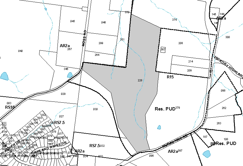
An ordinance to amend Title 17 of the Metropolitan Code of Laws, the Zoning Ordinance of The Metropolitan Government of Nashville and Davidson County, by amending a phase of the Residential Planned Unit Development located abutting the northwest margin of Rural Hill Road and the eastern margin of Moss Road, classified R15 and proposed for RM6 and RS10, (42.67 acres), to permit the development of 92 single-family lots and 85 condominium units to replace the approved and undeveloped 140 single-family lots, all of which is more particularly described herein, (Proposal No. 28-79-U-13).
NOW, THEREFORE, BE IT ENACTED BY THE COUNCIL OF THE METROPOLITAN GOVERNMENT
OF NASHVILLE AND DAVIDSON COUNTY:
Section 1. That Title 17 of the Code of Laws of The Metropolitan Government of Nashville and Davidson County, be and is hereby amended by making certain changes in the Official Zoning Map for Metropolitan Nashville and Davidson County, which is made a part of said Title 17 by reference, as follows:
By amending a phase of the Residential Planned Unit Development located abutting the northwest margin of Rural Hill Road and the eastern margin of Moss Road, classified R15 and proposed for RM6 and RS10, (42.67 acres), to permit the development of 92 single-family lots and 85 condominium units to replace the approved and undeveloped 140 single-family lots, as being Property Parcel No. 228 as designated on Map 149 of Official Property Identification Maps of The Metropolitan Government of Nashville and Davidson County, all of which is more particularly described by lines, words and figures on the attached plan, which is attached to and made a part of this ordinance as though copied herein.
Section 2. BE IT FURTHER ENACTED, That the Metropolitan Clerk is hereby authorized and directed, upon the enactment and approval of this ordinance, to cause the change to be made on Sheet No. 149 of said Official Zoning Map for Metropolitan Nashville and Davidson County, as set out in Section 1 of this ordinance, and to make notation thereon of reference to the date of passage and approval of this amendatory ordinance.
Section 3. Be it further resolved that the following conditions be completed or bonded prior to any final plat recordation for this portion of the PUD:
Section 4. BE IT FURTHER ENACTED, That this ordinance take effect immediately after its passage and such change be published in a newspaper of general circulation, the welfare of The Metropolitan Government of Nashville and Davidson County requiring it.
Sponsored by: Jason Alexander, Tony Derryberry
Owner/Map-Parcel No.:
J. E. Stevenson, Trustee
Map 149, Parcel 228 (42.67 acres)
Requested by:
Kevin Estes
Dale & Associates
|
LEGISLATIVE HISTORY |
|
|---|---|
| Introduced: | June 3, 2003 |
| Passed First Reading: | June 3, 2003 |
| Referred to: | Planning
Commission - Approved 10-0 (05/22/2003) Planning & Zoning Committee |
| Passed Second Reading: | July 8, 2003 |
| Deferred to August 5, 2003: | July 8, 2003 |
| Deferred: | August 5, 2003 |
| Passed Third Reading: | August 19, 2003 |
| Approved: | August 20, 2003 |
| By: | |
| Effective Date: | August 29, 2003 |