LEGISLATIVE HISTORY
Planning & Zoning Committee

ORDINANCE NO. BL2003-1396
An ordinance to amend Title 17 of the Metropolitan Code of Laws, the Zoning
Ordinance of The Metropolitan Government of Nashville and Davidson County,
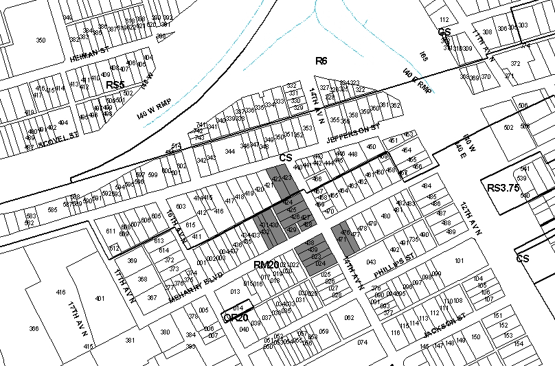
by changing from RM20 district to OR40 district properties at 1033, 1035,
1037, 1039, and 1041 14th Avenue North, and 1404, 1406, 1408 and 1408
1 Meharry Boulevard, at the intersection of Meharry Boulevard and 14th
Avenue North, (.98 acres), all of which is more particularly described
herein (Proposal No. 2003Z-018U-08).
NOW, THEREFORE, BE IT ENACTED BY THE COUNCIL OF THE METROPOLITAN GOVERNMENT
OF NASHVILLE AND DAVIDSON COUNTY:
Section 1. That Title 17 of the Code of Laws of The Metropolitan Government of Nashville and Davidson County, be and is hereby amended by making certain changes in the Official Zoning Map for Metropolitan Nashville and Davidson County, which is made a part of said Title 17 by reference, as follows:
By changing from RM20 district to OR40 district properties at 1033, 1035,
1037, 1039, and 1041 14th Avenue North, and 1404, 1406, 1408 and 1408 1 Meharry
Boulevard, at the intersection of Meharry Boulevard and 14th Avenue North,
(.98 acres), being more particularly described as being Property Parcel Nos.
424 through 432 as designated on Map 81-16 of the Official Property Identification
Maps of The Metropolitan Government of Nashville and Davidson County, all of
which is more particularly described by lines, words and figures on the attached
plan, which is attached to and made a part of this ordinance as though copied
herein.
Section 2. Be it further enacted, that the Metropolitan Clerk is hereby authorized
and directed, upon the enactment and approval of this ordinance, to cause
the change to be made on Sheet No. 81 of said Official Zoning Map for Metropolitan
Nashville and Davidson County, as set out in Section 1 of this ordinance,
and to make notation thereon of reference to the date of passage and approval
of this amendatory ordinance.
Section 3. Be it further enacted, that this ordinance take effect immediately
after its passage and such change be published in a newspaper of general
circulation, the welfare of The Metropolitan Government of Nashville and
Davidson County requiring it.
Sponsored by: Ludye N. Wallace
Owner/Map-Parcel
No.:
Mathew Walker Comprehensive Health Center, Inc.
Carol Creswell-Betsch et al
Map 81-16, Parcel 424 (.13 acres)
Mathew Walker
Comprehensive Health Center, Inc.
Kenneth Lee
Map 81-16, Parcel 427 (.13 acres), 426 (.13 acres), 430 (.20 acres)
Mathew Walker
Comprehensive Health Center, Inc.
Ernest A. Taylor
Map 81-16, Parcel 427 (.06 acres)
Mathew Walker
Comprehensive Health Center, Inc.
E.J. Kirshner et ux
Map 81-16, Parcel 428 (.06 acres)
Mathew Walker
Comprehensive Health Center, Inc.
Lowell Phillips
Map 81-16, Parcel 429 (.07 acres)
Mathew Walker
Comprehensive Health Center, Inc.
Map 81-16, Parcels 431 (.10 acres) and 432 (.10 acres)
Requested by:
Michael S. Delvizis, P.E.
Stantec Consulting Services
|
LEGISLATIVE HISTORY |
|
|---|---|
| Introduced: | April 1, 2003 |
| Passed First Reading: | April 1, 2003 |
| Referred to: | Planning
Commission - Approved 6-0 (1/23/2003) Planning & Zoning Committee |
| Passed Second Reading: | June 4, 2003 |
| Passed Third Reading: | June 17, 2003 |
| Approved: | June 19, 2003 |
| By: | |
| Effective Date: | June 21, 2003 |