LEGISLATIVE HISTORY
Planning & Zoning Committee
Education Committee

ORDINANCE NO. BL2003-1383
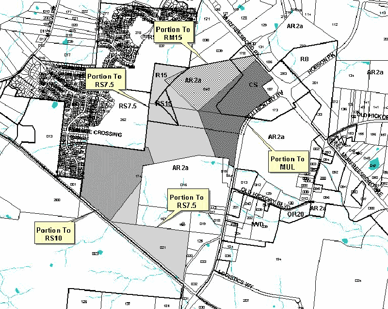
An ordinance to amend Title 17 of the Metropolitan Code of Laws, the Zoning Ordinance of The Metropolitan Government of Nashville and Davidson County, by changing from CS, AR2a, RS15, and R15 districts to MUL, RS10, RM15, and RS7.5 districts properties at 12786 Old Hickory Boulevard, Route 2 Murfreesboro Pike and Hobson Pike (unnumbered), at the intersection of Old Hickory Boulevard and Murfreesboro Pike, (238.97 acres), all of which is more particularly described herein (Proposal No. 2003Z-030G-13).
NOW, THEREFORE, BE IT ENACTED BY THE COUNCIL OF THE METROPOLITAN GOVERNMENT
OF NASHVILLE AND DAVIDSON COUNTY:
Section 1. That Title 17 of the Code of Laws of The Metropolitan Government of Nashville and Davidson County, be and is hereby amended by making certain changes in the Official Zoning Map for Metropolitan Nashville and Davidson County, which is made a part of said Title 17 by reference, as follows:
By changing from CS, AR2a, RS15, and R15 districts to MUL (55.2 acres), RS10
(54.5 acres), RM15 (40.27 acres), and RS7.5 (89.0 acres) districts properties
at 12786 Old Hickory Boulevard, Route 2 Murfreesboro Pike and Hobson Pike (unnumbered),
at the intersection of Old Hickory Boulevard and Murfreesboro Pike, (238.97
acres), being more particularly described as being Property Parcel Nos. 40
and 174 as designated on Map 164 and Property Parcel No. 21 as designated on
Map 175 of the Official Property Identification Maps of The Metropolitan Government
of Nashville and Davidson County, all of which is more particularly described
by lines, words and figures on the attached plan, which is attached to and
made a part of this ordinance as though copied herein.
Section 2. Be it further enacted, that the Metropolitan Clerk is hereby authorized
and directed, upon the enactment and approval of this ordinance, to cause
the change to be made on Sheet Nos. 164 and 175 of said Official Zoning Map
for Metropolitan Nashville and Davidson County, as set out in Section 1 of
this ordinance, and to make notation thereon of reference to the date of
passage and approval of this amendatory ordinance.
Section 3.
Be it further enacted, no final plat for development on the site shall be approved
until a school site, in compliance with the standards of
Section 17.16.040 for elementary schools with a capacity of 500 students,
shall be offered for dedication to the Metro Board of Education, the offer
of such school site being proportional to the development’s student
generation potential.
Section 4. Be it further enacted, a more detailed Traffic Impact Study (TIS) will be required with the submittal of a development plan to the Metro Planning Commission. The scope of the TIS is to be determined by Metro Planning Department and the Public Works Department.
Section 5. Be it further enacted, with the recording of a final plat the applicant will be required either to dedicate or reserve right-of-way for the proposed Southeast Arterial.
Section 6. Be it further enacted, that this ordinance take effect immediately
after its passage and such change be published in a newspaper of general circulation,
the welfare of The Metropolitan Government of Nashville and Davidson County
requiring it.
Sponsored by: Saletta Holloway, Jim Shulman
Owner/Map-Parcel No.:
Belz-McDowell Properties
Map 164, Parcel 40 (80.73 acres) and 174 (128.01 acres)
Map 175, Parcel 21 (30.23 acres)
Requested by:
Jerome Hanover
Belz-McDowell Properties
View Sketch
|
LEGISLATIVE HISTORY |
|
|---|---|
| Introduced: | April 1, 2003 |
| Passed First Reading: | April 1, 2003 |
| Referred to: | Planning
Commission - Approved 8-0 (3/13/2003) Planning & Zoning Committee Education Committee |
| Passed Second Reading: | May 6, 2003 |
| Deferred to June 3, 2003: | May 6, 2003 |
| Deferred: | June 3, 2003 |
| Passed Third Reading: | June 17, 2003 |
| Approved: | June 19, 2003 |
| By: | |
| Effective Date: | June 21, 2003 |