LEGISLATIVE HISTORY
Planning & Zoning Committee
Traffic & Parking Committee

ORDINANCE NO. BL2003-1381
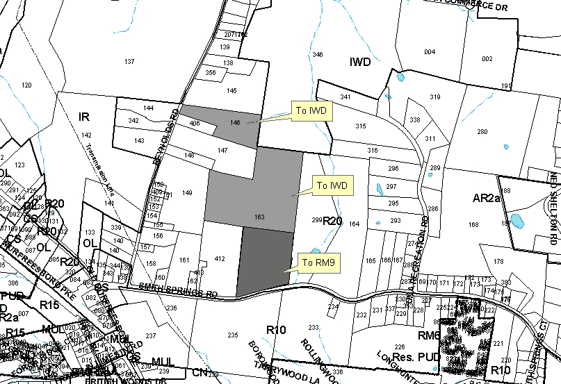
An ordinance to amend Title 17 of the Metropolitan Code of Laws, the Zoning Ordinance of The Metropolitan Government of Nashville and Davidson County, by changing from R20 district to RM9 and IWD districts properties at 1792 Reynolds Road and Smith Springs Road (unnumbered), abutting the northern margin of Smith Springs Road and the eastern margin of Reynolds Road, (40.27 acres), all of which is more particularly described herein (Proposal No. 2003Z-048U-13).
NOW, THEREFORE, BE IT ENACTED BY THE COUNCIL OF THE METROPOLITAN GOVERNMENT
OF NASHVILLE AND DAVIDSON COUNTY:
Section 1. That Title 17 of the Code of Laws of The Metropolitan Government of Nashville and Davidson County, be and is hereby amended by making certain changes in the Official Zoning Map for Metropolitan Nashville and Davidson County, which is made a part of said Title 17 by reference, as follows:
By changing from R20 district to RM9 and IWD districts properties at 1792
Reynolds Road and Smith Springs Road (unnumbered), abutting the northern margin
of Smith Springs Road and the eastern margin of Reynolds Road, (40.27 acres),
being more particularly described as being Property Parcel Nos. 163 and 146
as designated on Map 135 of the Official Property Identification Maps of The
Metropolitan Government of Nashville and Davidson County, all of which is more
particularly described by lines, words and figures on the attached plan, which
is attached to and made a part of this ordinance as though copied herein.
Section 2. Be it further enacted, that the Metropolitan Clerk is hereby authorized
and directed, upon the enactment and approval of this ordinance, to cause
the change to be made on Sheet No. 135 of said Official Zoning Map for Metropolitan
Nashville and Davidson County, as set out in Section 1 of this ordinance,
and to make notation thereon of reference to the date of passage and approval
of this amendatory ordinance.
Section 3. Be it further enacted, that this ordinance take effect immediately
after its passage and such change be published in a newspaper of general
circulation, the welfare of The Metropolitan Government of Nashville and
Davidson County requiring it.
Sponsored by: Tony Derryberry, Jim Shulman
Owner/Map-Parcel No.:
Charles F. and Joyce L. Galbreath
Map 135, Parcel 146 (6.96 acres)
J. E. Stevenson, Trustee
Map 135, Parcel 163 (33.31 acres)
Requested by:
J.E. Stevenson
View Sketch
Amendment No. 1
To
Ordinance No. BL2003-1381
Mr. President:
I move to amend Ordinance No. BL2003-1381 in the following manner:
1. By amending Section 1 by adding the phrase “(13.0 acres)” after the zoning designation “RM9” and by adding the phrase “(27.27 acres)” after the zoning designation “IWD”.
2. By substituting the associated map of the property referenced in Section 1 with the map attached as part of this amendment.
3. By adding the following new Section 4:
“Be it further enacted that the following conditions shall be met with the submittal of any subdivision plat or development application:
Sponsored by: Tony Derryberry
|
LEGISLATIVE HISTORY |
|
|---|---|
| Introduced: | April 1, 2003 |
| Passed First Reading: | April 1, 2003 |
| Referred to: | Planning
Commission - Approved 8-0 (06/26/2003) Planning & Zoning Committee Traffic & Parking Committee |
| Amended: | May 6, 2003 |
| Passed Second Reading: | May 6, 2003 |
| Deferred: | May 20, 2003 |
| Deferred to July 15, 2003: | June 3, 2003 |
| Passed Third Reading: | July 15, 2003 |
| Approved: | July 17, 2003 |
| By: | |
| Effective Date: | July 19, 2003 |