LEGISLATIVE HISTORY
Planning & Zoning Committee

ORDINANCE NO. BL2003-1380
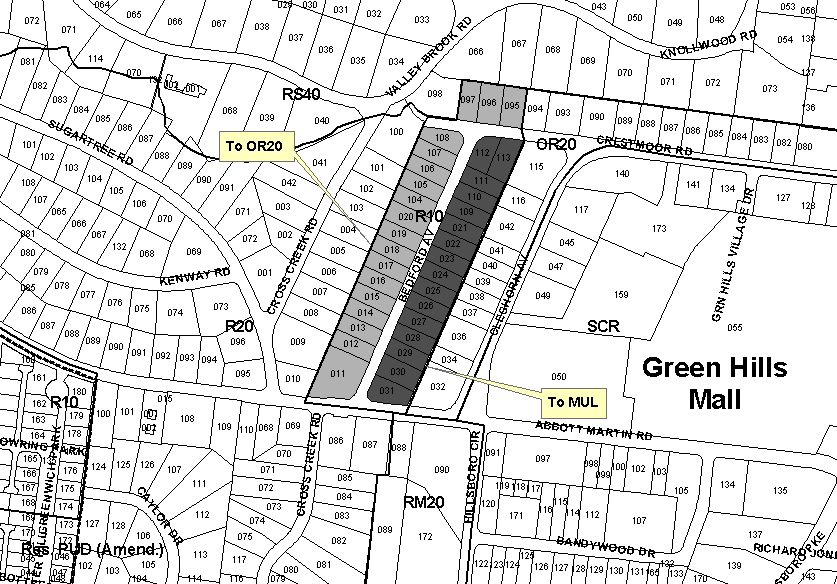
An ordinance to amend Title 17 of the Metropolitan Code of Laws, the Zoning Ordinance of The Metropolitan Government of Nashville and Davidson County, by applying the Urban Design Overlay (UDO) district to properties located at 2404 and 2406 Crestmoor Road, 2411, 2413, 2415 Crestmoor Road, 3800-3805 Bedford Avenue, 3807 and 3809 Bedford Avenue, and 3811-3830 Bedford Avenue, (12.19 total acres), to permit the development of a mixture of residential, office, and retail uses, all of which is more particularly described herein (Proposal No. 2003UD-002U-10).
NOW, THEREFORE, BE IT ENACTED BY THE COUNCIL OF THE METROPOLITAN GOVERNMENT
OF NASHVILLE AND DAVIDSON COUNTY:
Section 1. That Title 17 of the Code of Laws of The Metropolitan Government of Nashville and Davidson County, be and is hereby amended by making certain changes in the Official Zoning Map for Metropolitan Nashville and Davidson County, which is made a part of said Title 17 by reference, as follows:
By applying the
Urban Design Overlay (UDO) district to properties located at 2404 and 2406
Crestmoor Road, 2411, 2413, 2415 Crestmoor Road, 3800-3805
Bedford Avenue, 3807 and 3809 Bedford Avenue, and 3811-3830 Bedford Avenue,
(12.19 total acres), to permit the development of a mixture of residential,
office, and retail uses, being more particularly described as being Property
Parcel Nos. 95-97 and 104-113 as designed on Map 117-10 and Property Parcel
Nos. 11-31 as designated on Map 117-14 of the Official Property Identification
Maps of The Metropolitan Government of Nashville and Davidson County, all of
which is more particularly described by lines, words and figures in the attached
document entitled Bedford Avenue Urban Design Overlay, which is attached to
and made a part of this ordinance as though copied herein.
Section 2. Be it further enacted, that the Metropolitan Clerk is hereby authorized
and directed, upon the enactment and approval of this ordinance, to cause
the change to be made on Sheet No. 117 of said Official Zoning Map for Metropolitan
Nashville and Davidson County, as set out in Section 1 of this ordinance,
and to make notation thereon of reference to the date of passage and approval
of this amendatory ordinance.
Section 3. Be it further enacted, that this ordinance take effect immediately
after its passage and such change be published in a newspaper of general
circulation, the welfare of The Metropolitan Government of Nashville and
Davidson County requiring it.
Sponsored by: Jim Shulman
Owner/Map-Parcel No.:
William J. Wilson, III and Valarie L.
Map 117-10, Parcel 95 (.40 acres)
Elaine C. Beard
Map 117-10, Parcel 96 (.40 acres)
Nell M. Haggard
Map 117-10, Parcel 97 (.36 acres)
Clifford O. Richmond
Map 117-10, Parcel 104 (.30 acres), 105 (.30 acres), 106 (.30 acres),
109 (.29 acres), 110 (.29 acres), 111 (.29 acres)
Thomas C. & Grace M.
Paden
Map 117-10, Parcel 107 (.30 acres)
James Marshall Campbell, Jr. et ux
Map 117-10, Parcel 108 (.34 acres)
A. J. Smith, Jr.
Map 117-10, Parcel 112 (.35 acres)
Charles Graham et ux
Map 117-10, Parcel 113 (.41 acres)
Thomas Jere Neal
Map 117-14, Parcel 11 (.78 acres)
J. B. Elizer
Map 117-14, Parcel 12 (.36 acres)
Martha E. Fulks
Map 117-14, Parcel 13 (.36 acres)
Scott Leathers & Samuel
G. Craig
Map 117-14, Parcel 14 (.36 acres)
B. R. Robbins et ux
Map 117-14, Parcel 15 (.36 acres)
William & Mary Jean
Walker
Map 117-14, Parcel 16 (.36 acres)
Audrey C. Santi – Rev
Liv Trust
Map 117-14, Parcel 17 (.36 acres)
E. M. Bryan et ux
Map 117-14, Parcel 18 (.36 acres)
Henry J. Abbott
Map 117-14, Parcel 19 (.36 acres)
Clifford Richmond
Map 117-14, Parcel 20 (.36 acres)
Patricia Moss
Map 117-14, Parcel 21 (.34 acres)
Margaret M. Davenport
Map 117-14, Parcel 22 (.34 acres)
Steven Tyler
Map 117-14, Parcel 23 (.34 acres)
Verna Satterfield Rosswald
Map 117-14, Parcel 24 (.34 acres)
E. M. Rosswald et ux
Map 117-14, Parcel 25 (.34 acres)
Robert Andrew Sharp, Sr.
Map 117-14, Parcel 26 (.34 acres)
Robert A. Sharp, Sr.
Map 117-14, Parcel 27 (.34 acres)
Dorothy Craus
Map 117-14, Parcel 28 (.34 acres)
M. E. Bierly et ux
Map 117-14, Parcel 29 (.34 acres)
Lytle Brown, III
Map 117-14, Parcel 30 (.44 acres)
Sallie B. B. Smith
Map 117-14, Parcel 31 (.42 acres)
Requested by:
Councilmember Jim Shulman
View Sketch
AMENDMENT NO. 1
TO
ORDINANCE NO.
BL2003-1380
Mr. President:
I move to amend Ordinance No. BL2003-1380 by substituting the Bedford Avenue Urban Design Overlay Plan with the attached updated plan that contains an additional appendix (Appendix B) outlining the planning background and process that occurred in producing the document, as well as the modifications listed below.
1. Addition of
the following text on page 14 under “Objective 1:”
The park shall be named Max Bierly Park, in honor of Max Bierly.
2. Addition of
the following text on page 26:
Building and Use Permits. Nonresidential use of property located in this UDO
is permitted only within or accessory to buildings meeting the standards
in the Table of Bulk Standards in this appendix.
3. Deletion of
the following text on page 28 within item “c” under “UDO
District Perimeter Buffer:”
The buffer shall include provision of an earth berm that runs parallel to the
property line, and shall be planted with evergreen trees, deciduous understory
trees, and evergreen shrubs.
4. Addition of
the following text on page 28 within item “c” under “UDO
District Perimeter Buffer:”
The buffer shall include a stone or brick wall that runs parallel to the property
line, and shall be planted with evergreen trees, deciduous understory trees,
and evergreen shrubs. The wall shall be a minimum of eight (8) feet tall. In
areas where the health of existing, mature vegetation may be compromised by
the construction of the wall, a less invasive but no less attractive barrier
may be substituted, so long as the barrier is a minimum of eight (8) feet tall
and complements the architecture of the development. When a less invasive barrier
is utilized, the buffer may also include an earth berm in addition to the required
barrier and plantings.
5. Addition of
the following text on page 32 within “SECTION 4: PARKING
STANDARDS:”
3. Parking lot lighting: Lighting shall be appropriate in function and scale
for both the pedestrian and the vehicle. Lighting that minimizes light trespass,
pollution, and uplight shall be utilized. Luminaire styles, colors, and finishes
shall complement the architectural features of the development.
6. Addition
of the following text on page 32 within “Signs not permitted:”
Neon signs are prohibited within the UDO area.
7. Deletion of
the following text on page 32 within “Limitation on lighting:”
Exceptions: a) Neon lights are permitted if they form the lettering on a sign
and/or they are used to define a logo or a border.
8. Addition of
the following text on page 32 within “Placement of signs:”
Lighted signs are prohibited in the rear of buildings located on the west side
of Bedford Avenue and on the north side of Crestmoor Road.
Sponsored by: Jim Shulman
|
LEGISLATIVE HISTORY |
|
|---|---|
| Introduced: | April 1, 2003 |
| Passed First Reading: | April 1, 2003 |
| Referred to: | Planning
Commission - Approved 8-0 (3/27/2003) Planning & Zoning Committee |
| Passed Second Reading: | May 6, 2003 |
| Deferred to June 3, 2003: | May 6, 2003 |
| Deferred: | June 3, 2003 |
| Amended: | June 17, 2003 |
| Passed Third Reading: | June 17, 2003 |
| Approved: | June 19, 2003 |
| By: | |
| Effective Date: | June 21, 2003 |