LEGISLATIVE HISTORY
Planning & Zoning Committee

ORDINANCE NO. BL2003-1359
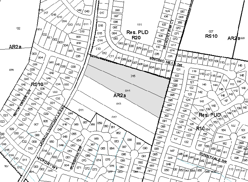
An ordinance to amend Title 17 of the Metropolitan Code of Laws, the Zoning Ordinance of The Metropolitan Government of Nashville and Davidson County, by changing from AR2a district to RS10 district properties at 4455 and 4459 Lavergne-Couchville Pike, abutting the eastern margin of Lavergne-Couchville Pike, (7.32 acres), all of which is more particularly described herein (Proposal No. 2003Z-043G-13).
NOW, THEREFORE, BE IT ENACTED BY THE COUNCIL OF THE METROPOLITAN GOVERNMENT
OF NASHVILLE AND DAVIDSON COUNTY:
Section 1. That Title 17 of the Code of Laws of The Metropolitan Government of Nashville and Davidson County, be and is hereby amended by making certain changes in the Official Zoning Map for Metropolitan Nashville and Davidson County, which is made a part of said Title 17 by reference, as follows:
By changing from from AR2a district to RS10 district properties at 4455 and 4459 Lavergne-Couchville Pike, abutting the eastern margin of Lavergne-Couchville Pike, (7.32 acres), being more particularly described as being Property Parcel Nos. 14 and 15 as designated on Map 176 of the Official Property Identification Maps of The Metropolitan Government of Nashville and Davidson County, all of which is more particularly described by lines, words and figures on the attached plan, which is attached to and made a part of this ordinance as though copied herein.Section 2. Be it further enacted, that the Metropolitan Clerk is hereby authorized and directed, upon the enactment and approval of this ordinance, to cause the change to be made on Sheet No. 176 of said Official Zoning Map for Metropolitan Nashville and Davidson County, as set out in Section 1 of this ordinance, and to make notation thereon of reference to the date of passage and approval of this amendatory ordinance.
Section 3. Be it further enacted, that this ordinance take effect immediately after its passage and such change be published in a newspaper of general circulation, the welfare of The Metropolitan Government of Nashville and Davidson County requiring it.
Sponsored by: Saletta Holloway
Owner/Map-Parcel No.:
Walter A. Scott and Beverly J. Scott
Map 176, Parcel 14 (3.68 acres)
Harrial Wayne Barrett et ux
Map 176, Parcel 15 (3.64 acres)
Requested by:
Nadine Y. Cummings
Cummings Premier Properties L.L.C.
|
LEGISLATIVE HISTORY |
|
|---|---|
| Introduced: | March 18, 2003 |
| Passed First Reading: | March 18, 2003 |
| Referred to: | Planning
Commission - Approved 7-0 (04/10/2003) Planning & Zoning Committee |
| Deferred: | May 6, 2003 |
| Deferred Indefinitely: | May 20, 2003 |
| Passed Second Reading: | June 3, 2003 |
| Passed Third Reading: | June 17, 2003 |
| Approved: | June 19, 2003 |
| By: | |
| Effective Date: | June 21, 2003 |