ORDINANCE NO. BL2003-1356
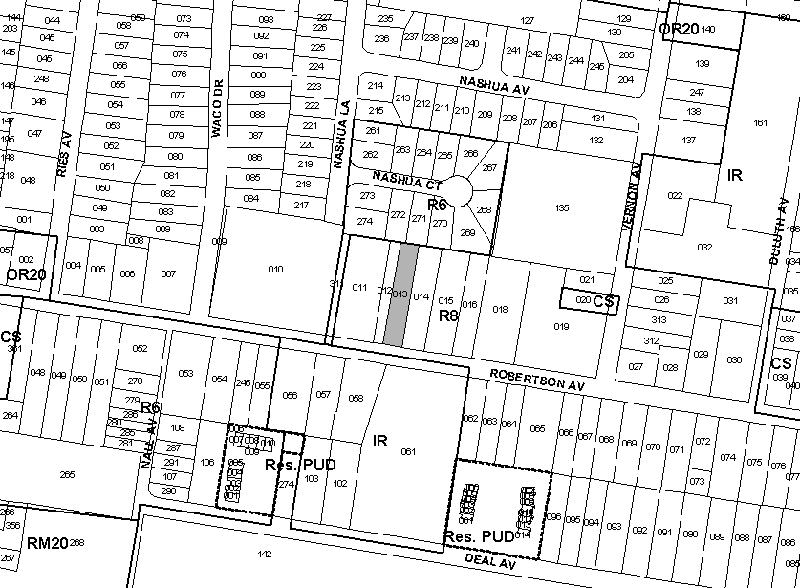
An ordinance to amend Title 17 of the Metropolitan Code of Laws, the Zoning Ordinance of The Metropolitan Government of Nashville and Davidson County, by changing from R8 district to CS district property at 6120 Robertson Avenue, approximately 500 feet west of Vernon Street, (.30 acres), all of which is more particularly described herein (Proposal No. 2002Z-109U-07).
NOW, THEREFORE, BE IT ENACTED BY THE COUNCIL OF THE METROPOLITAN GOVERNMENT
OF NASHVILLE AND DAVIDSON COUNTY:
Section 1. That Title 17 of the Code of Laws of The Metropolitan Government of Nashville and Davidson County, be and is hereby amended by making certain changes in the Official Zoning Map for Metropolitan Nashville and Davidson County, which is made a part of said Title 17 by reference, as follows:
By changing from R8 district to CS district property at 6120 Robertson Avenue, approximately 500 feet west of Vernon Street, (.30 acres), being more particularly described as being Property Parcel No. 13 as designated on Map 91-9 of the Official Property Identification Maps of The Metropolitan Government of Nashville and Davidson County, all of which is more particularly described by lines, words and figures on the attached plan, which is attached to and made a part of this ordinance as though copied herein.
Section 3. Be it further enacted, that this ordinance take effect immediately after its passage and such change be published in a newspaper of general circulation, the welfare of The Metropolitan Government of Nashville and Davidson County requiring it.
Sponsored by: Norma Hand
Owner/Map-Parcel No.:
Kenneth and Judy McCory
Map 91-9, Parcel 13 (.30 acres)
Requested by:
Kenneth & Judy McCoy
McCoys Garage
|
LEGISLATIVE HISTORY |
|
|---|---|
| Introduced: | March 18, 2003 |
| Passed First Reading: | March 18, 2003 |
| Referred to: | Planning
Commission - Disapproved 10-0 (12/12/2003) |
| Failed: | May 6, 2003 |