LEGISLATIVE HISTORY
Planning & Zoning Committee

ORDINANCE NO. BL2003-1323
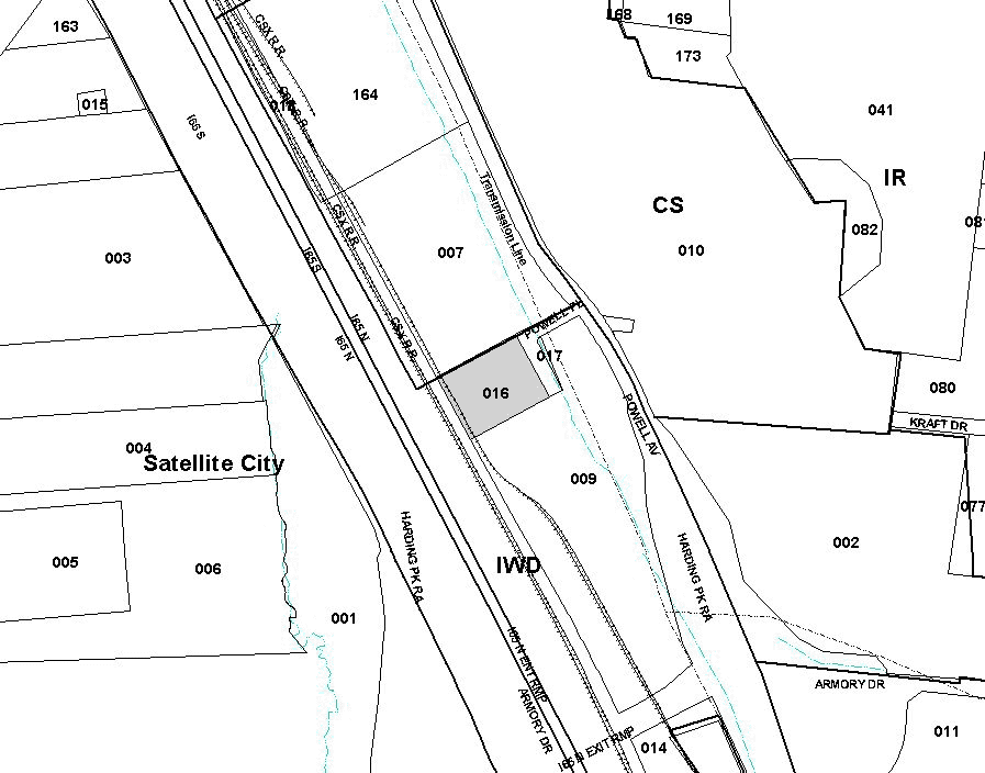
An ordinance to amend Title 17 of the Metropolitan Code of Laws, the Zoning Ordinance of The Metropolitan Government of Nashville and Davidson County, by changing from IWD district to CS district property at 100 Powell Place, abutting the southern side of Powell Place, (2.18 acres), all of which is more particularly described herein (Proposal No. 2003Z-031U-11).
NOW, THEREFORE, BE IT ENACTED BY THE COUNCIL OF THE METROPOLITAN GOVERNMENT
OF NASHVILLE AND DAVIDSON COUNTY:
Section 1. That Title 17 of the Code of Laws of The Metropolitan Government of Nashville and Davidson County, be and is hereby amended by making certain changes in the Official Zoning Map for Metropolitan Nashville and Davidson County, which is made a part of said Title 17 by reference, as follows:
By changing from IWD district to CS district property at 100 Powell Place,
abutting the southern side of Powell Place, (2.18 acres), being more particularly
described as being Property Parcel No. 16 as designated on Map 118-15 of the
Official Property Identification Maps of The Metropolitan Government of Nashville
and Davidson County, all of which is more particularly described by lines,
words and figures on the attached plan, which is attached to and made a part
of this ordinance as though copied herein.
Section 2. Be it further enacted, that the Metropolitan Clerk is hereby authorized
and directed, upon the enactment and approval of this ordinance, to cause
the change to be made on Sheet No. 118 of said Official Zoning Map for Metropolitan
Nashville and Davidson County, as set out in Section 1 of this ordinance,
and to make notation thereon of reference to the date of passage and approval
of this amendatory ordinance.
Section 3. Be it further enacted, that this ordinance take effect immediately
after its passage and such change be published in a newspaper of general
circulation, the welfare of The Metropolitan Government of Nashville and
Davidson County requiring it.
Sponsored by: Ron Turner, Leo Waters, Amanda McClendon
Map & Parcel
Nos./Owner:
Shurgard-Freeman 100 Oaks, L.L.C.
Map 118-15, Parcel 16
Requested by:
Ed Freeman
The Freeman Group
View Sketch
| LEGISLATIVE HISTORY |
|
|---|---|
| Introduced: | February 4, 2003 |
| Passed First Reading: | February 4, 2003 |
| Referred to: |
Planning Commission - Approved 8-0 (02/23/2003) Planning & Zoning Committee |
| Passed Second Reading: | March 4, 2003 |
| Passed Third Reading: | March 18, 2003 |
| Approved: | March 21, 2003 |
| By: | |
| Effective Date: | March 29, 2003 |