LEGISLATIVE HISTORY
Planning & Zoning Committee

ORDINANCE NO. BL2002-1223
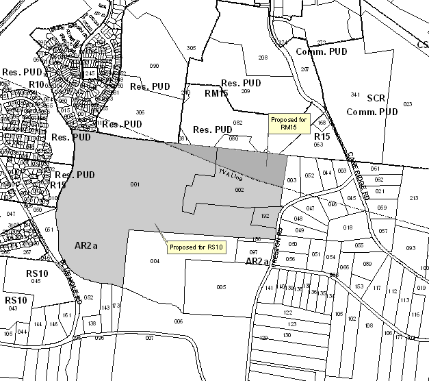
An ordinance to amend Title 17 of the Metropolitan Code of Laws, the Zoning Ordinance of The Metropolitan Government of Nashville and Davidson County, by changing from AR2a District to RS10 (131 acres) and RM15 (14 acres) Districts properties at 765 Preston Road and Preston Road (unnumbered), approximately 1,250 feet west of Cane Ridge Road, (145 acres total), all of which is more particularly described herein (Proposal No. 2002Z-075G-12).
NOW, THEREFORE, BE IT ENACTED BY THE COUNCIL OF THE METROPOLITAN GOVERNMENT
OF NASHVILLE AND DAVIDSON COUNTY:
Section 1. That Title 17 of the Code of Laws of The Metropolitan Government of Nashville and Davidson County, be and is hereby amended by making certain changes in the Official Zoning Map for Metropolitan Nashville and Davidson County, which is made a part of said Title 17 by reference, as follows:
By changing from
AR2a District to RS10 and RM15 Districts properties at 765 Preston Road and
Preston Road (unnumbered), approximately 1,250 feet west of Cane Ridge Road,
(145 acres), being more particularly described as being Property Parcel Nos.
1, 2 and 192 as designated on Map 174 of the Official Property Identification
Maps of The Metropolitan Government of Nashville and Davidson County, all of
which is more particularly described by lines, words and figures on the attached
plan, which is attached to and made a part of this ordinance as though copied
herein.
Section 2. Be it further enacted, that the Metropolitan Clerk is hereby authorized
and directed, upon the enactment and approval of this ordinance, to cause the
change to be made on Sheet No. 174 of said Official Zoning Map for Metropolitan
Nashville and Davidson County, as set out in Section 1 of this ordinance, and
to make notation thereon of reference to the date of passage and approval of
this amendatory ordinance.
Section 3. Be it further enacted, that this ordinance take effect immediately
after its passage and such change be published in a newspaper of general circulation,
the welfare of The Metropolitan Government of Nashville and Davidson County
requiring it.
Section 4. Be it
further enacted that the following conditions must be completed prior to final
plat recordation:
a. widening the pavement of Cane Ridge Road to Major Street Plan Standards (currently
U4) from the northern portion of parcel 168 on tax map 174 to the Cane Ridge
Road/Preston Road intersection;
b. upgrading the Cane Ridge Road/Preston Road intersection to a 90-degree intersection;
c. widening Preston Road to metro standards for a local road (23 feet of pavement)
from that intersection to the southern frontage of parcel 001 on tax map 174;
d. the new development shall tie into the stub street (Hickory Park Drive) to
the north;
e. a school site in compliance with the standards of Section 17.16.040 for elementary
schools with a capacity of 500 students shall be offered for dedication to the
Metro Board of Education.
Sponsored by: Leo
Waters
Map & Parcel
No./Owner:
Milton A. Paul
Map 174, Parcel 1 (110.82 acres)
Milton H. Paul,
Charles B. Paul and Allen G. Paul
Map 174, Parcel 2 (29.69 acres)
Charles A. and
Darinda Paul
Map 174, Parcel 192 (3.16 acres)
Requested by:
Roy M. Dale P.E.
Dale & Associates
516 Heather Place
Nashville, TN 37204
View Sketch
Amendment No. 1
To
Ordinance No. BL2002-1223
Mr. President:
I move to amend Ordinance No. BL2002-1223 as follows:
1. By deleting the Caption and replacing it with the following:
“An ordinance to amend Title 17 of the Metropolitan Code of Laws, the Zoning Ordinance of The Metropolitan Government of Nashville and Davidson County, by changing from AR2a District to RS10 (131 acres) and RM15 (14 acres) Districts properties at 765 Preston Road and Preston Road (unnumbered), approximately 1,250 feet west of Cane Ridge Road, (145 acres total), all of which is more particularly described herein (Proposal No. 2002Z-075G-12).”
2. By deleting the second paragraph of Section 1 and replacing it with the following:
“By changing from AR2a District to RS10 (131 acres) and RM15 (14 acres) Districts properties at 765 Preston Road and Preston Road (unnumbered), approximately 1,250 feet west of Cane Ridge Road, (145 acres total), being more particularly described as being Property Parcel Nos. 1, 2 and 192 as designated on Map 174 of the Official Property Identification Maps of The Metropolitan Government of Nashville and Davidson County, all of which is more particularly described by lines, words and figures on the attached plan, which is attached to and made a part of this ordinance as though copied herein.
3. By deleting Section 4 in its entirety and replacing it with the following:
“Section 4. Be it further enacted that the following conditions must be completed as set forth herein:
a. the new development shall tie into the stub street (Hickory Park Drive) to the north;
b. prior to the recordation of any final plat that includes buildable lots with access to Cane Ridge Road, that road shall be widened to Major Street Plan Standards (currently U4) from the northern portion of parcel 168 on tax map 174 to the Cane Ridge Road/Preston Road intersection, or such road improvements shall be bonded;
c. prior to the recordation of any final plat that includes buildable lots with access to Cane Ridge Road or Preston Road, the Cane Ridge Road/Preston Road intersection shall be reconstructed to a 90-degree intersection, or such intersection improvements shall be bonded;
d. prior to the recordation of any final plat that includes buildable lots with access to Preston Road, that road shall be widened to metro standards for a local road (23 feet of pavement) from the intersection of Preston Road and Cane Ridge Road to the southern frontage of parcel 001 on tax map 174, or such road improvements shall be bonded;
e. a school site in compliance with the standards of Section 17.16.040 for elementary schools with a capacity of 500 students shall be offered for dedication to the Metro Board of Education prior to final plat recordation.
Sponsored by: Leo
Waters
| LEGISLATIVE HISTORY |
|
|---|---|
| Introduced: | October 1, 2002 |
| Passed First Reading: | October 1, 2002 |
| Referred to: | Planning
Commission - Approved 8-1 (08/22/02) Planning & Zoning Committee |
| Deferred: | November 7, 2002 |
| Passed Second Reading: | November 19, 2002 |
| Passed Third Reading: | December 3, 2002 |
| Approved: | December 9, 2002 |
| By: | |
| Effective Date: | December 12, 2002 |