LEGISLATIVE HISTORY
Planning & Zoning Committee

ORDINANCE NO. BL2002-1082
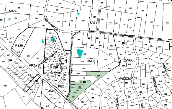
An ordinance to amend Title 17 of the Metropolitan Code of Laws, the Zoning Ordinance of The Metropolitan Government of Nashville and Davidson County, by changing from R40 District to RM4 District properties at 1900, 1906, 1910 and 1914 Tinnin Road, at the intersection of Tinnin Road and Springfield Highway, (6.26 acres), all of which is more particularly described herein (Proposal No. 2002Z-033G-02).
NOW, THEREFORE, BE IT ENACTED BY THE COUNCIL OF THE METROPOLITAN GOVERNMENT OF NASHVILLE AND DAVIDSON COUNTY:
Section 1. That Title 17 of the Code of Laws of The Metropolitan Government of Nashville and Davidson County, be and is hereby amended by making certain changes in the Official Zoning Map for Metropolitan Nashville and Davidson County, which is made a part of said Title 17 by reference, as follows:
By changing from R40 District
to RM4 District properties at 1900, 1906, 1910 and 1914 Tinnin Road, at the
intersection of Tinnin Road and Springfield Highway, (6.26 acres), being more
particularly described as being Property Parcel Nos. 198, 199, 200 and 201 as
designated on Map 7 of the Official Property Identification Maps of The Metropolitan
Government of Nashville and Davidson County, all of which is more particularly
described by Exhibit A, lines, words and figures on the attached plan, which
is attached to and made a part of this ordinance as though copied herein.
Section 2. Be it further enacted, that the Metropolitan Clerk is hereby authorized
and directed, upon the enactment and approval of this ordinance, to cause the
change to be made on Sheet No. 7 of said Official Zoning Map for Metropolitan
Nashville and Davidson County, as set out in Section 1 of this ordinance, and
to make notation thereon of reference to the date of passage and approval of
this amendatory ordinance.
Section 3. Be it further enacted, that this ordinance take effect immediately after its passage and such change be published in a newspaper of general circulation, the welfare of The Metropolitan Government of Nashville and Davidson County requiring it.
EXHIBIT A
No access shall be provided to Springfield Highway from parcels 198 - 201 on tax map 7 per the Metro Traffic Engineer.
A dedication of five (5) feet of right-of-way along the properties frontage on Tinnin Road shall be shown on the associated Planned Unit Development (PUD) plan for Magnolia Station Condominiums (2002P-002G-02). Tinnin Road is a planned collector street with an ultimate right-of-way width of 60 feet. Today, it has only 50 feet of right-of-way.
A reserveation of 36 feet of right-of-way on Springfield Highway along the property's frontage (parcel 198 on tax map 7) shall be shown on the PUD plan for Magnolia Station Condominiums (2002P-002G-02). Springfield Highway has an ultimate planned arterial street right-of-way width of 172 feet.
Map & Parcel No./Owner:
7-198,199, 200 & 201 Richard Uselton - R . J. Par Co., Inc.
Sponsored By: Jim Shulman, Bettye Balthrop
|
LEGISLATIVE HISTORY |
|
|---|---|
| Introduced: | June 4, 2002 |
| Passed First Reading: | June 4, 2002 |
| Referred to: | Planning
Commission - Approved 6-0 (5/23/02) Planning & Zoning Committee |
| Passed Second Reading: | July 2, 2002 |
| Passed Third Reading: | July 16, 2002 |
| Approved: | July 17, 2002 |
| By: | |