LEGISLATIVE HISTORY
Planning & Zoning Committee

ORDINANCE NO. BL2000-553
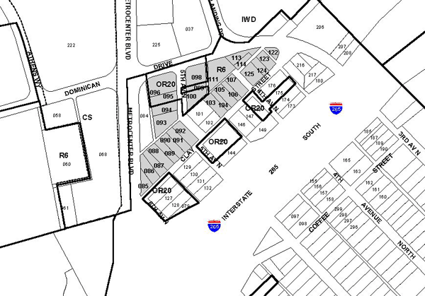
An ordinance to amend Title 17 of the Metropolitan Code of Laws, the Zoning Ordinance of The Metropolitan Government of Nashville and Davidson County, by changing from R6 and OR20 Districts to MUL District 27 properties between MetroCenter Boulevard, Clay Street, and Dominican Drive (4.16 acres), (Proposal No. 2000Z-133U-08), all of which is more particularly described herein.
NOW, THEREFORE, BE IT ENACTED BY THE COUNCIL OF THE METROPOLITAN GOVERNMENT OF NASHVILLE AND DAVIDSON COUNTY:
SECTION 1. That Title 17 of the Code of Laws of The Metropolitan Government of Nashville and Davidson County, be and is hereby amended by making certain changes in the Official Zoning Map for Metropolitan Nashville and Davidson County, which is made a part of said Title 17 by reference, as follows:
By changing from R6 and OR20 Districts to MUL District 27 properties between
MetroCenter Boulevard, Clay Street, and Dominican Drive (4.16 acres), being more
particularly described as being Property Parcel Nos. 85-96, 98-100, 103?107, 111, 113, 114
and 122-125 as designated on Map 81-4 of the Official Property Identification Maps of The
Metropolitan Government of Nashville and Davidson County, all of which is more
particularly described by lines, words and figures on the attached plan, which is attached
to and made a part of this ordinance as though copied herein.
SECTION 2. BE IT FURTHER ENACTED, That the Metropolitan Clerk is hereby authorized and
directed, upon the enactment and approval of this ordinance, to cause the change to be
made on Sheet No. 81 of said Official Zoning Map for Metropolitan Nashville and Davidson
County, as set out in Section 1 of this ordinance, and to make notation thereon of
reference to the date of passage and approval of this amendatory ordinance.
SECTION 3. BE IT FURTHER ENACTED, That this ordinance take effect immediately after its passage and such change be published in a newspaper of general circulation, the welfare of The Metropolitan Government of Nashville and Davidson County requiring it.
Map & Parcel No./Owner:
MetroCenter, Inc.
512 Clay Street, Map 81-4, Parcel 85 (.20 acres)
510 Clay Street, Map 81-4, Parcel 86 (.19 acres)
Clay Street (unnumbered), Map 81-4, Parcel 87 (.14 acres)
508 Clay Street, Map 81-4, Parcel 88 (.18 acres)
Clay Street (unnumbered), Map 81-4, Parcel 89 (.13 acres)
504 Clay Street, Map 81-4, Parcel 90 (.14 acres)
Clay Street (unnumbered), Map 81-4, Parcel 91 (.13 acres)
500 Clay Street, Map 81-4, Parcel 92 (.16 acres)
20007 5th Avenue North, Map 81-4, Parcel 93 (.23 acres)
5th Avenue North (unnumbered), Map 81-4, Parcel 99 (.05 acres)
408 Clay Street, Map 81-4, Parcel 104 (.08 acres)
402 Clay Street, Map 81-4, Parcel 106 (.16 acres)
400 Clay Street, Map 81-4, Parcel 107 (.14 acres)
2011 4th Avenue North, Map 81-4, Parcel 111 (.32 acres)
2006 4th Avenue North, Map 81-4, Parcel 113 (.12 acres)
2004 4th Avenue North, Map 81-4, Parcel 114 (.08 acres)
312 Clay Street, Map 81-4, Parcel 125 (.18 acres)
CB&J Properties, LLC
2009 5th Avenue North, Map 81-4, Parcel 94 (.14 acres)
2011 5th Avenue North, Map 81-4, Parcel 95 (.16 acres)
5th Avenue North (unnumbered), Map 81-4, Parcels 96 (.32 acres) and 98 (.25 acres)
2006 5th Avenue North, Map 81-4, Parcel 100 (.17 acres)
Felix Wade
410 Clay Street, Map 81-4, Parcel 103 (.16 acres)
Strickland Enterprises
404 Clay Street, Map 81-4, Parcel 105 (.08 acres)
306 Clay Street, Map 81-4, Parcel 122 (.04 acres)
308 Clay Street, Map 81-4, Parcel 123 (.12 acres)
310 Clay Street, Map 81-4, Parcel 124 (.09 acres)
Requested by: Wood Caldwell - Southeast Venture, LLC
Sponsored by: Morris Haddox
LEGISLATIVE HISTORY |
|
|---|---|
| Introduced: | December 5 , 2000 |
| Passed First Reading: | December 5 , 2000 |
| Referred to: | Planning
Commission - Approved 7-0 (11/9/00) Planning & Zoning Committee |
| Passed Second Reading: | January 2, 2001 |
| Passed Third Reading: | January 16, 2001 |
| Approved: | January 24, 2001 |
| By: | |
| Effective Date: | January 27, 2001 |