LEGISLATIVE HISTORY
Planning Commission - Disapproved 8-0 (5/25/00)
Planning Commission - Disapproved 8-0 (3/1/01)
Planning Commisison - Approved 6-0 (2/28/02)
Planning & Zoning Committee

ORDINANCE NO. BL2000-394
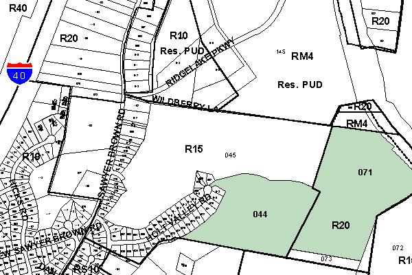
An ordinance to amend Title 17 of the Metropolitan Code of Laws, the Zoning Ordinance of The Metropolitan Government of Nashville and Davidson County, by changing from R15 and R20 Districts to RM4 District properties at Sawyer Brown Road (unnumbered) and Old Hickory Boulevard (unnumbered), approximately 1,900 feet south of Ridgelake Parkway (58.81 acres), (Proposal No. 2000Z-073G-06), all of which is more particularly described herein.
NOW, THEREFORE, BE IT ENACTED BY THE COUNCIL OF THE METROPOLITAN GOVERNMENT OF NASHVILLE AND DAVIDSON COUNTY:
SECTION 1. That Title 17 of the Code of Laws of The Metropolitan Government of Nashville and Davidson County, be and is hereby amended by making certain changes in the Official Zoning Map for Metropolitan Nashville and Davidson County, which is made a part of said Title 17 by reference, as follows:
By changing from R15 and R20 Districts to RM4 District properties at Sawyer Brown Road (unnumbered) and Old Hickory Boulevard (unnumbered), approximately 1,900 feet south of Ridgelake Parkway (58.81 acres), being more particularly described as being Property Parcel Nos. 71 and 44 as designated on Map 128 the Official Property Identification Maps of The Metropolitan Government of Nashville and Davidson County, all of which is more particularly described by lines, words and figures on the attached plan, which is attached to and made a part of this ordinance as though copied herein.
SECTION 2. BE IT FURTHER ENACTED, That the Metropolitan Clerk is hereby authorized and directed, upon the enactment and approval of this ordinance, to cause the change to be made on Sheet No. 128 said Official Zoning Map for Metropolitan Nashville and Davidson County, as set out in Section 1 of this ordinance, and to make notation thereon of reference to the date of passage and approval of this amendatory ordinance.
SECTION 3. BE IT FURTHER ENACTED, That this ordinance take effect immediately after its passage and such change be published in a newspaper of general circulation, the welfare of The Metropolitan Government of Nashville and Davidson County requiring it.
Map & Parcel No./Owner:
R. Hutton Buchanan et ux
Map 128, Parcels 71 (32.5 acres) and 44 (26.31 acres)
Requested by: McNiel & Company Real Estate
Sponsored by: Bob Bogen
Amendment No. 1
to
Ordinance No. BL2000-394
Mr. President:
I moved to amend Ordinance BL2000-394 by deleting the phrases "Property Parcels Nos. 44 and 71" and "58.81 acres" as they appear in the bills caption, Section 1 and attached sketch and substituting in leue thereof "Property Parcel No. 71" and "32.50 acres", respectively.
Sponsored by: Bob Bogen
Amendment Adopted: April 2, 2002
|
LEGISLATIVE HISTORY |
|
|---|---|
| Introduced: | August 15, 2000 |
| Passed First Reading: | August 15, 2000 |
| Referred to: |
Planning Commission - Disapproved 8-0 (5/25/00) |
| Deferred Indefinitely: | November 9, 2000 |
| Re-referred to Planning Commission: | February 5, 2002 |
| Deferred to March 19, 2002 | February 5, 2002 |
| Passed Second Reading: | March 19, 2002 |
| Amended: | April 2, 2002 |
| Passed Third Reading: | April 2, 2002 |
| Approved: | April 3, 2002 |
| By: | |