ORDINANCE NO. BL2000-393
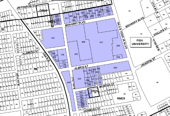
An ordinance to amend Title 17 of the Metropolitan Code of Laws, the Zoning Ordinance of The Metropolitan Government of Nashville and Davidson County, by changing from RM20 District to MUG District 69 properties between the east margin of the CSX Railroad and the west margin of D. B. Todd Boulevard, abutting the north and south margins of Meharry Boulevard, Albion Street, and Morena Street (29.09 acres) and from OR20 District to MUG District one property at 1909 Morena Street (.19 acres), (Proposal No. 2000Z-017U-08), all of which is more particularly described herein.
NOW, THEREFORE, BE IT ENACTED BY THE COUNCIL OF THE METROPOLITAN GOVERNMENT OF NASHVILLE AND DAVIDSON COUNTY:
SECTION 1. That Title 17 of the Code of Laws of The Metropolitan Government of Nashville and Davidson County, be and is hereby amended by making certain changes in the Official Zoning Map for Metropolitan Nashville and Davidson County, which is made a part of said Title 17 by reference, as follows:
By changing from RM20 District to MUG District 69 properties between the east margin of the CSX Railroad and the west margin of D. B. Todd Boulevard, abutting the north and south margins of Meharry Boulevard, Albion Street, and Morena Street being more particularly described as being Property Parcel Nos. 48-52, 90, 127-130, 136-140, 246-265, 267, 268, 282, 288-294, 300, 317-325, 329, 331, 359-365, 400, 402, and 405-406 (28.99 acres) as designated on Map 92-3 and Property Parcel No. 20 as designated on Map 92-7 (.10 acres) and from OR20 District to MUG District one property at 1909 Morena Street Property Parcel No. 333 as designated on Map 92-3 (.19 acres) of the Official Property Identification Maps of The Metropolitan Government of Nashville and Davidson County, all of which is more particularly described by lines, words and figures on the attached plan, which is attached to and made a part of this ordinance as though copied herein.
SECTION 2. BE IT FURTHER ENACTED, That the Metropolitan Clerk is hereby authorized and directed, upon the enactment and approval of this ordinance, to cause the change to be made on Sheet No. 92 of said Official Zoning Map for Metropolitan Nashville and Davidson County, as set out in Section 1 of this ordinance, and to make notation thereon of reference to the date of passage and approval of this amendatory ordinance.
SECTION 3. BE IT FURTHER ENACTED, That this ordinance take effect immediately after its passage and such change be published in a newspaper of general circulation, the welfare of The Metropolitan Government of Nashville and Davidson County requiring it.
Map & Parcel No./Owner:
RM20 to MUG District
Junior Spencer
Map 92-3, Parcel 49 (.14 acres)
Meharry Medical College, Inc.
Map 92-3, Parcels 48 (.09 acres), 50 (.07 acres), 51 (.07 acres), 52 (.14 acres), 90 (2.9
acres),
127 (.07 acres ), 128 (.09 acres), 129 (.07 acres), 130 (.20 acres), 136 (.71 acres), 137
(.18 acres), 138 (.18 acres), 139 (.12 acres),
140 (.17 acres), 255 (.10 acres), 258 (.10 acres), 264 (.10 acres), 267 (.40 acres), 268
(.26 acres), 282 (2.12 acres), 289 (.18 acres), 290 (.11 acres), 291 (.11 acres), 292 (.11
acres), 293 (.18 acres), 294 (.09 acres), 300 (1.79 acres), 317 (.09 acres), 318 (.09
acres), 319 (.18 acres), 320 (.11 acres), 321 (.13 acres), 322 (.13 acres), 323 (.07
acres), 324 (.07 acres), 325 (.13 acres), 329 (1.54 acres), 331 (.18 acres), 359 (.09
acres), 360 (.09 acres), 361 (.09 acres), 362 (.14 acres), 363 (.15 acres), 364 (.15
acres), 365 (.15 acres), 400 (1.42 acres), 405 (6.09 acres), 406 (3.80 acres)
Map 92-7, Parcel 20 (.10 acres)
William H. Council
Map 92-3, Parcel 246 (.22 acres)
J. W. King Jr. et ux
Map 92-3, Parcel 247 (.11 acres)
Eva R. Harns
Map 92-3, Parcels 248 (.11 acres) and 249 (.25 acres)
Gratin Fields et ux
Map 92-3, Parcel 250 (.11 acres)
Fannie J. Hankins
Map 92-3, Parcel 251 (.11 acres)
Addie Jackson Ray
Map 92-3, Parcel 252 (.11 acres)
Marguenta Neblett and Cerella A. Lucas
Map 92-3, Parcel 253 (.20 acres)
Lois H. Gueringer
Map 92-3 Parcel 254 (.20 acres)
T. J. Harris et ux and W. S. Moore
Map 92-3, Parcel 256 (.10 acres)
Jon Mac Randall et ux
Map 92-3, Parcel 257 (.20 acres)
Rogers Jordan
Map 92-3, 259 (.10 acres)
The Protestant Episcopal Church
Map 92-3, Parcels 260 (.10 acres), and 261 (.27 acres)
John S. Stone & Gertrude Jane
Map 92-3, Parcels 262 (.20 acres) and 263 (.13 acres)
Dr. John S. Stone II et ux
Map 92-3, Parcel 265 (.30 acres)
Industrial Development Board of Metro Government
Map 92-3, Parcels 288 (.18 acres) and 402 (.25 acres)
OR20 to MUG District
Yvonne C. Brandon
Map 92-3, Parcel 333 (.19 acres)
Requested by: Meharry Medical College
Sponsored by: Ludye Wallace
AMENDMENT NO. 1
TO
ORDINANCE NO. BL2000-393
Mr. President:
I move to amend Ordinance No. BL2000-393 by amending Section 1 thereof by deleting the following parcels of property from the required zone change and, further, by incorporating the revised sketch confirming the properties being deleted:
Map & Parcel No. Property Owner
92-3-49 Junior Spencer
92-3-251 Fannie Hankins
92-3-259 Rogers Jordan
92-3-288 Metropolitan Government
92-3-246 William Council
92-3-252 Addie Ray
92-3-260 Protestant Episcopal Church
92-3-333 Yvonne C. Brandon
92-3-247 J. W. King, Jr.
92-3-253 Lucas Neblett
92-3-261 Protestant Episcopal Church
92-3-402 Metropolitan Government
92-3-248 Eva R. Harris
92-3-254 Lois Gueringer
92-3-262 John Stone
92-3-249 Eva R. Harris
92-3-256 T. J. Harris, Jr.
92-3-263 John Stone
92-3-250 Gratin Fields
92-3-257 Jon Randall
92-3-265 Dr. John Stone, II
Sponsored by: Ludye Wallace
Amendment Adopted: November 21, 2000
LEGISLATIVE HISTORY |
|
|---|---|
| Introduced: | August 15, 2000 |
| Passed First Reading: | August 15, 2000 |
| Referred to: | Planning
Commission - Approved 8-0 (2/3/00) Planning & Zoning Committee |
| Passed Second Reading: | November 9, 2000 |
| Amended: | November 21, 2000 |
| Passed Third Reading: | November 21, 2000 |
| Returned Unsigned by Mayor: | November 29, 2000 |
| Effective Date: | December 2, 2000 |