LEGISLATIVE HISTORY
Planning & Zoning Committee

ORDINANCE NO. BL2000-349
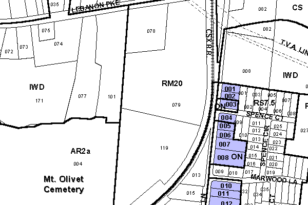
An ordinance to amend Title 17 of the Metropolitan Code of Laws, the Zoning Ordinance of The Metropolitan Government of Nashville and Davidson County, by changing from ON District and RS7.5 Districts to CS District properties at 220, 222, 224, 226, 228, 230, 248, 300, 400, 402, 406, and 408 Spence Lane, approximately 830 feet south of Lebanon Pike (5.94 acres), (Proposal No. 2000Z-081U-14), all of which is more particularly described herein.
NOW, THEREFORE, BE IT ENACTED BY THE COUNCIL OF THE METROPOLITAN GOVERNMENT OF NASHVILLE AND DAVIDSON COUNTY:
SECTION 1. That Title 17 of the Code of Laws of The Metropolitan Government of Nashville and Davidson County, be and is hereby amended by making certain changes in the Official Zoning Map for Metropolitan Nashville and Davidson County, which is made a part of said Title 17 by reference, as follows:
By changing from ON District and RS7.5 District to CS District properties at 220, 222, 224, 226, 228, 230, 248, 300, 400, 402, 406, and 408 Spence Lane, approximately 830 feet south of Lebanon Pike (5.94 acres), being more particularly described as being Property Parcel Nos. 1-8 and 10-12 as designated on Map 94-15, and Property Parcel No. 1 as designated on Map 106-3 the Official Property Identification Maps of The Metropolitan Government of Nashville and Davidson County, all of which is more particularly described by lines, words and figures on the attached plan, which is attached to and made a part of this ordinance as though copied herein.
SECTION 2. BE IT FURTHER ENACTED, That the Metropolitan Clerk is hereby authorized and directed, upon the enactment and approval of this ordinance, to cause the change to be made on Sheet Nos. 94 and 106 said Official Zoning Map for Metropolitan Nashville and Davidson County, as set out in Section 1 of this ordinance, and to make notation thereon of reference to the date of passage and approval of this amendatory ordinance.
SECTION 3. BE IT FURTHER ENACTED, That this ordinance take effect immediately after its passage and such change be published in a newspaper of general circulation, the welfare of The Metropolitan Government of Nashville and Davidson County requiring it.
Map & Parcel No./Owner:
Thomas B. Shockley et ux
Map 106-3, Parcel 1 (.67 acres)
Noble W. Brown et ux
Map 94-15, Parcel 11 (.52 acres)
G. M. Irwin et ux
Map 94-15, Parcel 14 (.03 acres)
Jack R. Winfrey et ux
Map 94-15, Parcel 3 (.34 acres)
Lela Pearl Harville
Map 94-15, Parcel 2 (.30 acres)
William E. Pickron
Map 94-15, Parcel 1 (.30 acres)
Todd E. and Chancie Goodwin
Map 94-15, Parcel 12 (.69 acres)
Edward M. Lusky et ux
Map 94-15, Parcel 10 (.52 acres)
James Ray
Map 94-15, Parcel 8 (1.03 acres)
David Brent Martin
Map 94-15, Parcel 7 (.67 acres)
John T. and Mary E. Filson et al
Map 94-15, Parcel 6 (.30 acres)
D. L. and Helen D. Batts
Map 94-15, Parcel 5 (.30 acres)
Requested by: James Ray
Sponsored by: J.B. Loring
LEGISLATIVE HISTORY |
|
|---|---|
| Introduced: | July 18, 2000 |
| Passed First Reading: | July 18, 2000 |
| Referred to: | Planning
Commission - Approved 8-0 (6/8/00) Planning & Zoning Committee |
| Passed Second Reading: | September 5, 2000 |
| Passed Third Reading: | September 19, 2000 |
| Approved: | September 21, 2000 |
| By: | |
| Effective Date: | September 23, 2000 |