LEGISLATIVE HISTORY
Planning & Zoning Committee

ORDINANCE NO. BL2000-259
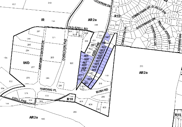
An ordinance to amend Title 17 of the Metropolitan Code of Laws, the Zoning Ordinance of The Metropolitan Government of Nashville and Davidson County, by changing from AR2a and R10 Districts to CS District properties at 404, 412, 414, 416, 418, 420, 423, 424, 425, 428, 429, 432, 433, 434, 437, 439, 440, 441, 442, 443, 444 Ezell Pike and Ezell Pike (unnumbered), abutting both the east and west margins of Ezell Pike between Harding Place and Southwind Drive (21.03 acres), (Proposal No. 2000Z-058U-13), all of which is more particularly described herein.
NOW, THEREFORE, BE IT ENACTED BY THE COUNCIL OF THE METROPOLITAN GOVERNMENT OF NASHVILLE AND DAVIDSON COUNTY:
SECTION 1. That Title 17 of the Code of Laws of The Metropolitan Government of Nashville and Davidson County, be and is hereby amended by making certain changes in the Official Zoning Map for Metropolitan Nashville and Davidson County, which is made a part of said Title 17 by reference, as follows:
By changing from AR2a and R10 Districts to CS District properties at 404, 412, 414, 416, 418, 420, 423, 424, 425, 428, 429, 432, 433, 434, 437, 439, 440, 441, 442, 443, 444 Ezell Pike and Ezell Pike (unnumbered), abutting both the east and west margins of Ezell Pike between Harding Place and Southwind Drive (21.03 acres), being more particularly described as being Property Parcel Nos. 147 and 150 as designated on Map 134, as being Property Parcel Nos. 5 thru 12 and 32 thru 40, 43 and 44 as designated on Map 134-8, as being Property Parcel No. 1 as designated on Map 134-12 of the Official Property Identification Maps of The Metropolitan Government of Nashville and Davidson County, all of which is more particularly described by lines, words and figures on the attached plan, which is attached to and made a part of this ordinance as though copied herein.
SECTION 2. BE IT FURTHER ENACTED, That the Metropolitan Clerk is hereby authorized and directed, upon the enactment and approval of this ordinance, to cause the change to be made on Sheet No. 134 of said Official Zoning Map for Metropolitan Nashville and Davidson County, as set out in Section 1 of this ordinance, and to make notation thereon of reference to the date of passage and approval of this amendatory ordinance.
SECTION 3. BE IT FURTHER ENACTED, That this ordinance take effect immediately after its passage and such change be published in a newspaper of general circulation, the welfare of The Metropolitan Government of Nashville and Davidson County requiring it.
Map & Parcel No./Owner:
134-147 & 150 Don C. & Margaret A. Bruce
134-8-38 Juanita Ervin
134-8-37 J. R. Foster et ux
134-8-12 Betty G. Shore
134-8-43 Marshall E. Mullis
134-8-35 Mohamed R. & Hanauk Abogamiza
134-8-34 James R. & Cynthia A. Henry
134-8-11 Charles F. Harrison et ux
134-8-39 James H. Connelly et ux
134-8-40 Malcolm L. Barrett et ux, Map 134-8, Parcel 40 (1.17 acres)
134-8-7 James K. Haynes et ux
134-8-36 Peter J. Sulinski, Jr.
134-8-5 Robert N. Copeland et ux
134-8-32 & 33 Ray C. Pulley et ux
134-8-8 Troy C., Margo J. & Troy A. Varney
134-8-9 Daniel B. Shearer et ux
134-8-10 Malcolm L. Barrett Sr. et ux
134-8-44 Thurman W. Allred et ux
134-8-6 Parker Rentals L.P.
134-12-1 E. M. Headrick et ux
Requested by: Linda DeMith-Sulinski
Sponsored by: Janis Sontany
AMENDMENT NO. 1
TO
ORDINANCE NO. BL2000-259
Mr. President:
I move to amend Ordinance No. BL2000-259 by deleting the phrases "433", "134-8-8 Troy C., Margo J. & Troy A. Varney", and "Property Parcel Nos. 5 thru 12" as they appear in the bill’s caption, Section 1 and attached sketch and substituting in lieu thereof "Property Parcel Nos. 5, 6, 7, and 9-12".
Sponsored by: Janis Sontany
Amendment Adopted: May 2, 2000
LEGISLATIVE HISTORY |
|
|---|---|
| Introduced: | April 4, 2000 |
| Passed First Reading: | April 4, 2000 |
| Referred to: | Planning
Commission - Approved 6-0 (4/27/00) Planning & Zoning Committee |
| Amended: | May 2, 2000 |
| Passed Second Reading: | May 2, 2000 |
| Passed Third Reading: | May 16, 2000 |
| Approved: | May 18, 2000 |
| By: | |
| Effective Date: | June 1, 2000 |