LEGISLATIVE HISTORY
Planning & Zoning Committee

ORDINANCE NO. BL2000-231
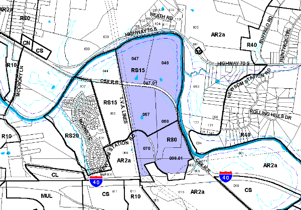
An ordinance to amend Title 17 of the Metropolitan Code of Laws, the Zoning Ordinance of The Metropolitan Government of Nashville and Davidson County, by making applicable to property abutting both margins of Newsom Station Road, south of Highway 70 South, classified RS15 District and R80 District and a portion proposed for RM2 District (332.04 acres), the provisions of a Planned Unit Development District, to permit 604 residential units comprised of 446 single-family lots and 158 townhome units, a pool, clubhouse and playground with access from Newsom Station Road and a one mile long greenway trail along the Harpeth River (2000P-003G-06), all of which is more particularly described herein.
NOW, THEREFORE, BE IT ENACTED BY THE COUNCIL OF THE METROPOLITAN GOVERNMENT OF NASHVILLE AND DAVIDSON COUNTY:
SECTION 1. That Title 17 of the Code of Laws of The Metropolitan Government of Nashville and Davidson County, be and is hereby amended by making certain changes in the Official Zoning Map for Metropolitan Nashville and Davidson County, which is made a part of said Title 17 by reference, as follows:
By making applicable to property abutting both margins of Newsom Station Road, south of Highway 70 South, classified RS15 District and R80 District and a portion proposed for RM2 District (332.04 acres), the provisions of a Planned Unit Development District, to permit 604 residential units comprised of 446 single-family lots and 158 townhome units, a pool, clubhouse and playground with access from Newsom Station Road and a one mile long greenway trail along the Harpeth River, being more particularly described as being Property Parcel Nos. 47, 47.01, 48, 67, 68, and 70 as designated on Map 126 and as being Property Parcel No. 8.01 on Map 140 of the Official Property Identification Maps of The Metropolitan Government of Nashville and Davidson County, all of which is more particularly described by lines, words and figures on the attached plan, which is attached to and made a part of this ordinance as though copied herein.
SECTION 2. BE IT FURTHER ENACTED, That the Metropolitan Clerk is hereby authorized and directed, upon the enactment and approval of this ordinance, to cause the change to be made on Sheet Nos. 126 and 140 of said Official Zoning Map for Metropolitan Nashville and Davidson County, as set out in Section 1 of this ordinance, and to make notation thereon of reference to the date of passage and approval of this amendatory ordinance.
SECTION 3. BE IT FURTHER ENACTED, That this ordinance take effect immediately after its passage and such change be published in a newspaper of general circulation, the welfare of The Metropolitan Government of Nashville and Davidson County requiring it.
Map & Parcel No./Owner:
126-47, 47.01, 48, 67, 68 & 70 Adelaide S. Robb and J. M. Davis, trustees et al.
140-8.01 Adelaide S. Robb and J. M. Davis, trustees et al.
Requested by: Barge, Waggoner, Sumner, and Cannon
Optionee: Crosland, Patton and Smith LLC
Sponsored by: Bob Bogen
AMENDMENT NO. 1
TO
ORDINANCE NO. BL2000-231
Mr. President:
I move to amend Ordinance No. BL2000-231 by deleting the number of lots/units as they appear in Section 1 and attached sketch and substituting in lieu thereof as follows:
Sponsored by: Bob Bogen
LEGISLATIVE HISTORY |
|
|---|---|
| Introduced: | April 4, 2000 |
| Passed First Reading: | April 4, 2000 |
| Referred to: | Planning
Commission - Approved 8-0 (6/13/00) Planning & Zoning Committee |
| Passed Second Reading: | May 2, 2000 |
| Deferred to June 20, 2000: | May 16, 2000 |
| Amended: | June 20, 2000 |
| Passed Third Reading: | June 20, 2000 |
| Approved: | June 22, 2000 |
| By: | |
| Effective Date: | June 26, 2000 |