LEGISLATIVE HISTORY
Planning & Zoning Committee

ORDINANCE NO. BL2000-162
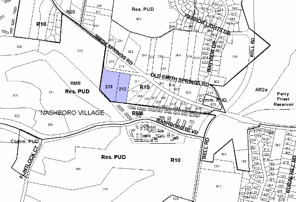
An ordinance to amend Title 17 of the Metropolitan Code of Laws, the Zoning Ordinance of The Metropolitan Government of Nashville and Davidson County, by changing from R10 District to RM6 District properties on the south margin of Old Smith Springs Road, approximately 280 feet south of Smith Springs Road (4.88 acres), (Proposal No. 99Z-104U-13), all of which is more particularly described herein.
NOW, THEREFORE, BE IT ENACTED BY THE COUNCIL OF THE METROPOLITAN GOVERNMENT OF NASHVILLE AND DAVIDSON COUNTY:
SECTION 1. That Title 17 of the Code of Laws of The Metropolitan Government of Nashville and Davidson County, be and is hereby amended by making certain changes in the Official Zoning Map for Metropolitan Nashville and Davidson County, which is made a part of said Title 17 by reference, as follows:
By changing from R10 District to RM6 District properties on the south margin of Old Smith Springs Road, approximately 280 feet south of Smith Springs Road (4.88 acres), being more particularly described as being Property Parcel Nos. 212 and 213 as designated on Map 135 of the Official Property Identification Maps of The Metropolitan Government of Nashville and Davidson County, all of which is more particularly described by lines, words and figures on the attached plan, which is attached to and made a part of this ordinance as though copied herein.
SECTION 2. BE IT FURTHER ENACTED, That the Metropolitan Clerk is hereby authorized and directed, upon the enactment and approval of this ordinance, to cause the change to be made on Sheet No. 135 of said Official Zoning Map for Metropolitan Nashville and Davidson County, as set out in Section 1 of this ordinance, and to make notation thereon of reference to the date of passage and approval of this amendatory ordinance.
SECTION 3. BE IT FURTHER ENACTED, That this ordinance take effect immediately after its passage and such change be published in a newspaper of general circulation, the welfare of The Metropolitan Government of Nashville and Davidson County requiring it.
Map & Parcel No./Owner:
135-212 & 213 WDN Properties, LTD. (publicly traded REIT)
Requested by: LDI Design, LLC for Vastland Nashboro Development, LLC
Sponsored by: Janis Sontany & Don Majors
LEGISLATIVE HISTORY |
|
|---|---|
| Introduced: | February 1, 2000 |
| Passed First Reading: | February 1, 2000 |
| Referred to: | Planning
Commission - 7-0 (1/6/00) Planning & Zoning Committee |
| Passed Second Reading: | March 7, 2000 |
| Passed Third Reading: | March 21, 2000 |
| Approved: | March 27, 2000 |
| By: | |
| Effective Date: | March 29, 2000 |