LEGISLATIVE HISTORY
Planning & Zoning Committee

ENACTED 08/17/1999
ORDINANCE NO. O99-1745
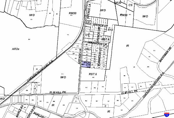
An ordinance to amend Title 17 of the Metropolitan Code of Laws, the Zoning Ordinance of The Metropolitan Government of Nashville and Davidson County, by changing from ON District to RS7.5 District properties at 422 and 424 Spence Lane, approximately 870 feet north of Elm Hill Pike (1.45 acres), (Proposal No. 99Z-095U), all of which is more particularly described herein.
NOW, THEREFORE, BE IT ENACTED BY THE COUNCIL OF THE METROPOLITAN GOVERNMENT OF NASHVILLE AND DAVIDSON COUNTY:
SECTION 1. That Title 17 of the Code of Laws of The Metropolitan Government of Nashville and Davidson County, be and is hereby amended by making certain changes in the Official Zoning Map for Metropolitan Nashville and Davidson County, which is made a part of said Title 17 by reference, as follows:
By changing from ON District to RS7.5 District properties at 422 and 424 Spence Lane, approximately 870 feet north of Elm Hill Pike (1.45 acres), being more particularly described as being Property Parcel Nos. 5 (.52 acres), 5.01 (.34 acres) and 6 (.59 acres) as designated on Map 106-3 of the Official Property Identification Maps of The Metropolitan Government of Nashville and Davidson County, all of which is more particularly described by lines, words and figures on the attached plan, which is attached to and made a part of this ordinance as though copied herein.
SECTION 2. BE IT FURTHER ENACTED, That the Metropolitan Clerk is hereby authorized and directed, upon the enactment and approval of this ordinance, to cause the change to be made on Sheet No. 106 of said Official Zoning Map for Metropolitan Nashville and Davidson County, as set out in Section 1 of this ordinance, and to make notation thereon of reference to the date of passage and approval of this amendatory ordinance.
SECTION 3. BE IT FURTHER ENACTED, That this ordinance take effect immediately after its passage and such change be published in a newspaper of general circulation, the welfare of The Metropolitan Government of Nashville and Davidson County requiring it.
Map & Parcel No./Owner:
160-3-5, 5.01 & 6 Floyd Duncan et ux
Requested by: Councilmember Roy Dale
Sponsored by: Roy Dale
LEGISLATIVE HISTORY |
|
|---|---|
| Introduced: | June 1, 1999 |
| Passed First Reading: | June 1, 1999 |
| Referred to: | Planning
Commission - Approved 8-0 (7/8/99) Planning & Zoning Committee |
| Deferred: | July 8, 1999; July 20, 1999 |
| Passed Second Reading: | August 3, 1999 |
| Passed Third Reading: | August 17, 1999 |
| Approved: | August 20, 1999 |
| By: | |
| Effective Date: | August 25,1999 |